
History, 19.04.2021 18:20 Josephcastillo6403
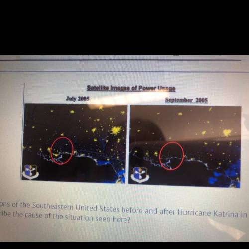
This light map shows regions of the Southeastern United States before and after Hurricane Katrina in 2005. Which of these
answers would BEST describe the cause of the situation seen here?
A) Poorly maintained levees failed to hold back the water in New Orleans,
resulting in catastrophic power outages.
B) Tornadoes spawned by the hurricane destroyed most of the towns in
northeastern Louisiana and southern Mississippi.
c) Nuclear power plants were overwhelmed by the storm surge, resulting in a
meltdown that polluted the area and killed many people.
D) The near-total evacuation of northeastern Louisiana and southern
Mississippi meant that there were no people in cities and towns when the
storm hit.

Answers: 3


Another question on History
History, 22.06.2019 06:30
This passage best represents which of these theories in the declaration of independence?
Answers: 3
History, 22.06.2019 11:00
Match your vocabulary word to its definition. 1. hectare reduced ability of the soil to support life 2. land degradation of spain and portugal 3. mangrove the pressing of soil particles closer together reducing the amount of air between particles 4. salinization 2.5 acres 5. junta group that controls the government 6. iberian small tropical tree 7. compaction higher than normal salt content in the soil
Answers: 1
You know the right answer?
This light map shows regions of the Southeastern United States before and after Hurricane Katrina in...
Questions
History, 03.03.2020 03:32


Mathematics, 03.03.2020 03:32


