
Geography, 13.08.2021 19:20 xthatshepoxy
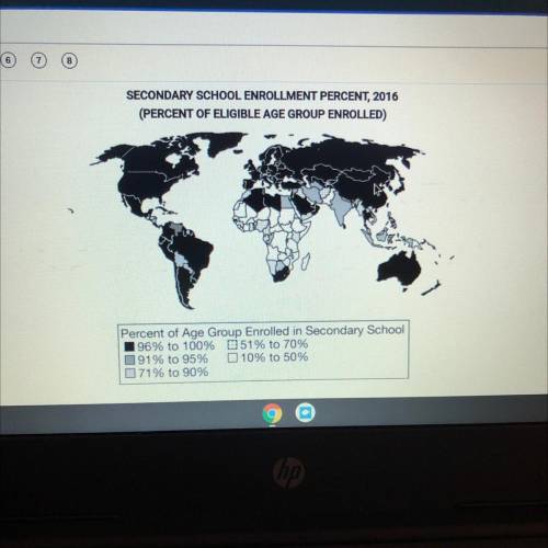
Which of the following spatial patterns accurately describes the data presented in the map?
А)
Most continents have countries with secondary school enrollments below 75 percent.
B)
There are no countries in Africa with secondary school enrollments above 90 percent.
с
The majority of countries with less than 70 percent secondary school enrollment are in sub-Saharan Africa.
D
The secondary school enrollment is proportional to population density.
E
Landlocked countries have secondary school enrollments above 90 percent.

Answers: 3


Another question on Geography
Geography, 22.06.2019 09:30
How do ocean currents affect temperature? check all that apply. they carry cold water from the poles to the equator and cool air over land. they flow north and then south below the equator. they flow south and then north above the equator. they move warm water from the equator to the poles and heat air over land. they move east to west and create prevailing winds. they move west to east and create seasonal winds.
Answers: 3
Geography, 22.06.2019 18:30
Stone mountain was formed during the formation of the blue ridge mountains around 300-350 million years ago and is considered part of the appalachian mountains. it formed as a result of the upwelling of magma from within the earth's crust. this upwelling, or solidified to form the that became stone mountain.
Answers: 1
Geography, 23.06.2019 09:30
Astate's representation in the u.s. senate is based on a) equal representation. b) the state's population. c) the state's electoral votes. d) the size of their major cities.this independent regulatory agency was created in 1974 to oversee and regulate the financing of political campaigns in the united states. a) warren cthis independent regulatory agency was created in 1974 to oversee and regulate the financing of political campaigns in the united states. a) warren commission (wc) b) federal election commission (fec) c) equal opportunity commission (eoc) d) securities and exchange commission (sec)
Answers: 1
Geography, 23.06.2019 16:00
If we review the changes in the landscape surrounding the great salt lake in utah we can see a change in topography. look at the area to the south of the lake. what change has occurred during the last twenty-nine years? a) erosion of the hills b) an increase in marshland c) flooding of the area and the development of wetlands d) deposition of sediments and an increase in elevation
Answers: 1
You know the right answer?
Which of the following spatial patterns accurately describes the data presented in the map?
А)
Questions


History, 12.08.2020 08:01
Mathematics, 12.08.2020 08:01
Mathematics, 12.08.2020 08:01

Mathematics, 12.08.2020 08:01
Mathematics, 12.08.2020 08:01

Mathematics, 12.08.2020 08:01
Mathematics, 12.08.2020 08:01
Mathematics, 12.08.2020 08:01

English, 12.08.2020 08:01


