
Geography, 08.03.2021 03:50 smithsa10630
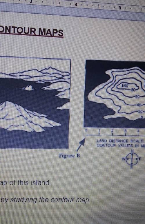
This island starts at see level. how do you know
what is the countour interval of this map?
which side of the mountain has the gentlest slope? north south east or west
how do you know ?
which side of the mountain has the steepest slope? north south east or west
How do you know?
how high is the peak or this island?

Answers: 1


Another question on Geography
Geography, 22.06.2019 08:30
Topographic maps are used to measure a-composition b-movement c-elevation d-texture
Answers: 1
Geography, 23.06.2019 20:30
What is the latitude and longitude (to the nearest degree) of the following cities? a. kansas city b. philadelphia c. reno d. minneapolis use the map to find the names of cities with the following coordinates. a. 30°n, 96°w b. 35°n, 95°w c. 26°n, 80°w d. 42°n, 88°w how many kilometers north of the equator is washington, dc? approximately how far north of houston is kansas city? use degrees of latitude to calculate your answer. show your work. which city is closer to greenwich, england: los angeles or xi’an, china (34°n, 109°e)? explain your answer. how many degrees of longitude separate las vegas from the international date line, which is at 180° longitude?
Answers: 1
Geography, 24.06.2019 02:00
What are mountains that divide european russia from asian russia?
Answers: 1
You know the right answer?
This island starts at see level. how do you know
what is the countour interval of this map?
Questions

Biology, 02.05.2021 23:40


Business, 02.05.2021 23:40

Mathematics, 02.05.2021 23:40
Mathematics, 02.05.2021 23:40
Mathematics, 02.05.2021 23:40
Mathematics, 02.05.2021 23:40

Biology, 02.05.2021 23:40
Mathematics, 02.05.2021 23:40
Mathematics, 02.05.2021 23:40
Biology, 02.05.2021 23:40
Mathematics, 02.05.2021 23:40
Chemistry, 02.05.2021 23:40


