
Geography, 21.12.2020 20:40 monsterduckgoose
Analyze the image below and answer the question that follows.
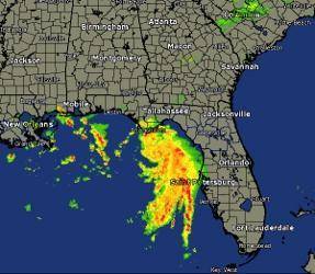
A map of the Southeastern U S used for weather forecasting.
Image courtesy of the National Weather Service
Analyze the image above. Which remote sensing technology uses radio waves to observe and predict weather?
A. aerial photography
B. radar
C. GIS
D. GPS
Please select the best answer from the choices provided
A
B
C
D

Answers: 3


Another question on Geography
Geography, 23.06.2019 15:00
The oil and gas found in the middle east are regulated by a. organization of petroleum exporting countries b. southwestern asian oil refineries c. north atlantic treaty organization
Answers: 1
Geography, 24.06.2019 00:00
The ethnic conflicts in darfur have led to an attempt to destroy a whole people known as
Answers: 1
You know the right answer?
Analyze the image below and answer the question that follows.
A map of the Southeastern U S used...
Questions

Mathematics, 24.08.2019 03:50

History, 24.08.2019 03:50


Biology, 24.08.2019 04:00
Mathematics, 24.08.2019 04:00
Mathematics, 24.08.2019 04:00

Social Studies, 24.08.2019 04:00
Mathematics, 24.08.2019 04:00
English, 24.08.2019 04:00
Mathematics, 24.08.2019 04:00
Mathematics, 24.08.2019 04:00
Social Studies, 24.08.2019 04:00

Computers and Technology, 24.08.2019 04:00


